Dennis Deery
 Growing up in southwest Wisconsin, tornado watches and warnings were a constant feature of summer life. As a little kid, I can remember trips to the basement to wait out the storm, and when I got a little older I got to join Dad on tornado watch for the local volunteer fire department. I can still vividly remember the night the tornado hit Barneveld, Wisconsin, and the phone rang in the middle of the night calling for ambulance volunteers. A few weeks later Dad and I went to Barneveld for a day to help with cleanup, and it remains one of the most amazing displays of nature’s power that I’ve ever seen.
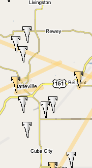
The University of Michigan Department of Atmospheric, Oceanic and Space Sciences has created a Google map mashup that allows you to view tornado paths overlaid on an interactive map. Using Google Earth, you can even fly a bird’s-eye view of the tornado path. Their database includes tornadoes from 1950 to 2005. You can search for tornadoes by date, strength and zip code. Looking at this map of my hometown, it certainly looks like a dangerous place to live!
This site is also a great example of the Google Map interface that allows programmers to overlay data on interactive Google maps. This is a great tool for presenting geographic data without a lot of work or cost. Google has launched an initiative to help nonprofit organizations present data to support their causes - check out the gallery.
Finally, a couple of examples of Google maps that I’ve done for client sites: